Condition Report
Contact Information
Auction Specialist
Lot 533
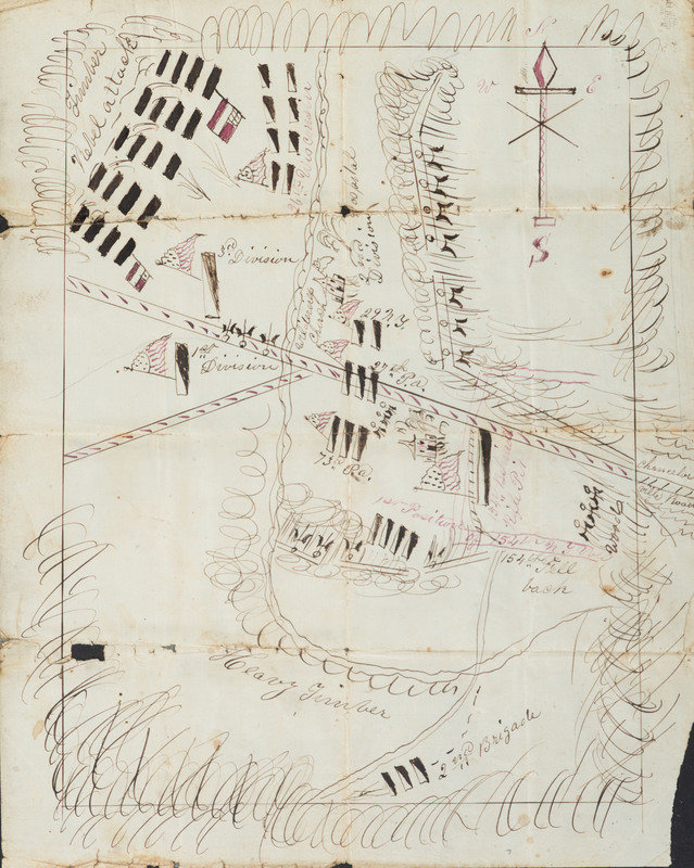
[CIVIL WAR]. Hand-drawn map showing the defeat of the XI Corps by the flanking march of Stonewall Jackson's at the Battle of Chancellorsville. [Chancellorsville, VA], [1863].
Sale 1095 - American Historical Ephemera & Photography, Featuring Property from the James Milgram, M.D., Collection of Broadsides, Ephemeral Americana & Historical Documents
Day 1 Lots 1-403
Nov 3, 2022
10:00AM ET
Day 2 Lots 404-634
Nov 4, 2022
10:00AM ET
Live / Cincinnati
Own a similar item?
Estimate
$700 -
1,000
Price Realized
$594
Sold prices are inclusive of Buyer’s Premium
Lot Description
[CIVIL WAR]. Hand-drawn map showing the defeat of the XI Corps by the flanking march of Stonewall Jackson's at the Battle of Chancellorsville. [Chancellorsville, VA], [1863].
7 3/4 x 9 3/4 in. hand-drawn map in red and black ink (separations and small losses along original folds, small marginal loss to lower left, minor toning); framed to 10 1/4 x 13 1/4 in. (not examined out of frame).
A HAND-DRAWN BATTLE MAP DEPICTING STONEWALL JACKSON'S FINAL MILITARY ENGAGEMENT, THE DRAMATIC SURPRISE ATTACK AGAINST THE XI CORPS AT THE BATTLE OF CHANCELLORSVILLE.
A hand-drawn battle map showing the XI Corps on 2 May 1863 when they were surprise attacked by a flanking force led by Stonewall Jackson (1824-1863).
At the Battle of Chancellorsville, the Army of the Potomac newly under the command of General Joseph Hooker met the Army of Northern Virginia commanded by General Robert E. Lee. Hooker was on the offensive in a Southern thrust and Lee hoped to stymie the effort. Hooker’s force was much larger, and Lee took a risky, but ultimately effective approach by splitting up his force and charging General Stonewall Jackson and his entire Corps with an aggressive flanking maneuver.
The XI Corps was stationed on the far-right flank on the Orange Turnpike, past Wilderness Church, and communications problems on both 2 May and the preceding day led to a lack of support and General Oliver O. Howard made no provisions for surprise attacks, despite orders from Hooker. They were stationed with no natural obstacles except deep forests which they (incorrectly) assumed would not be navigable by an approaching force. Hooker’s only plans for the XI Corps were for skirmishing after the main battle and did not expect them to be heavily involved.
The XI Corps, the smallest in the U.S. Army, was not a well-respected unit with little history of battle success. Composed largely of German immigrants, many political refugees from the 1848 revolutions, they had been previously led by General Franz Sigel, who though popular among his troops was inept. When Sigel attempted to enlarge the Corps and his request was denied, he angrily resigned and was replaced by General Oliver O. Howard. He became deeply unpopular with his men, however, in part due to his strong evangelical religious beliefs which earned him the moniker the “Christian general.”
On the day of May 2, despite increasing reports of possible enemy approach within the forest among enlisted men, officers refused to take notice. Near 5:30 p.m., most of the XI Corps was seated for supper, however, they witnessed animals fleeing from the western woods and then heard the “Rebel Yell” as Jackson’s cavalry advanced out of the forest in a surprise attack. Despite resistance, the XI Corps were entirely overwhelmed by Jackson’s assault. The loss to the corps was 2,407 casualties with 217 killed, 1,218 wounded, and 972 captured.
The daring flank attack proved to be Stonewall Jackson’s last. When returning from camp, the 18th North Carolina Infantry mistook the General and his staff for a Union cavalry force and fired at the men. Jackson was hit by three bullets, forcing the amputation of his arm, and died 8 days later on 10 May 1863 from complications from pneumonia.
The map here, though undated, appears to be near contemporaneous to the events. Within a border, the artist has alluded to the thick forests, labeling it “Heavy Timber.” The roads and the Wilderness Church are labeled and the positions of Union troops, each with an American flag, are noted: 1st Division and 3rd Division on either side of the road on the western edge, with the 26th Wisconsin Infantry (2nd Brigade, 3rd Division) farther north than the rest of its Division. Farther east the units of the 1st Brigade, 2nd Division are labeled with their positions: 29th New York, 27th Pennsylvania, 73rd Pennsylvania, and the original position of the 154th New York and where they fell back to. In the upper right, Jackson’s troops are labeled “Rebel attack” with 2 Confederate national flags.
Property from the James Milgram, M.D., Collection of Broadsides, Ephemeral Americana, and Historical Documents

